


Lake & Mendocino Counties PUMA, California
About
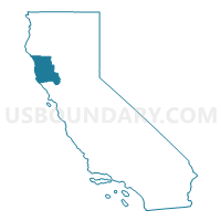
Outline

Summary
| Unique Area Identifier | 192262 |
| Name | Lake & Mendocino Counties PUMA |
| State | California |
| Area (square miles) | 5,207.56 |
| Land Area (square miles) | 4,762.81 |
| Water Area (square miles) | 444.76 |
| % of Land Area | 91.46 |
| % of Water Area | 8.54 |
| Latitude of the Internal Point | 39.34963470 |
| Longtitude of the Internal Point | -123.25696510 |
Maps

Graphs
Select a template below for downloading or customizing gragh for Lake & Mendocino Counties PUMA, California


Neighbors
Neighoring Public Use Microdata Area (by Name) Neighboring Public Use Microdata Area on the Map
- Colusa, Glenn, Tehama & Trinity Counties PUMA, CA
- Humboldt County PUMA, CA
- Napa County--Napa City PUMA, CA
- Sonoma County (North)--Windsor Town, Healdsburg & Sonoma Cities PUMA, CA
- Yolo County--Davis, Woodland & West Sacramento Cities PUMA, CA
Top 10 Neighboring County (by Population) Neighboring County on the Map
- Sonoma County, CA (483,878)
- Yolo County, CA (200,849)
- Napa County, CA (136,484)
- Humboldt County, CA (134,623)
- Mendocino County, CA (87,841)
- Lake County, CA (64,665)
- Tehama County, CA (63,463)
- Glenn County, CA (28,122)
- Colusa County, CA (21,419)
- Trinity County, CA (13,786)
Top 10 Neighboring County Subdivision (by Population) Neighboring County Subdivision on the Map
- Ukiah CCD, Mendocino County, CA (27,163)
- Russian River-Sonoma Coast CCD, Sonoma County, CA (22,713)
- Orland CCD, Glenn County, CA (17,598)
- Clearlake CCD, Lake County, CA (15,849)
- Cloverdale-Geyserville CCD, Sonoma County, CA (13,648)
- Garberville CCD, Humboldt County, CA (13,518)
- Willits CCD, Mendocino County, CA (13,120)
- Fort Bragg CCD, Mendocino County, CA (12,178)
- Redwood Valley-Potter Valley CCD, Mendocino County, CA (12,032)
- Mendocino CCD, Mendocino County, CA (10,609)
Top 10 Neighboring Place (by Population) Neighboring Place on the Map
- Ukiah city, CA (16,075)
- Clearlake city, CA (15,250)
- Fort Bragg city, CA (7,273)
- Hidden Valley Lake CDP, CA (5,579)
- Willits city, CA (4,888)
- Lakeport city, CA (4,753)
- Kelseyville CDP, CA (3,353)
- North Lakeport CDP, CA (3,314)
- Brooktrails CDP, CA (3,235)
- Clearlake Riviera CDP, CA (3,090)
Top 10 Neighboring Elementary School District (by Population) Neighboring Elementary School District on the Map
- Upper Lake Union Elementary School District, CA (5,462)
- Lucerne Elementary School District, CA (3,417)
- Arena Union Elementary School District, CA (3,252)
- Horicon Elementary School District, CA (1,641)
- Reeds Creek Elementary School District, CA (1,281)
- Alexander Valley Union Elementary School District, CA (871)
- Pope Valley Union Elementary School District, CA (791)
- Manchester Union Elementary School District, CA (640)
- Elkins Elementary School District, CA (271)
Top 10 Neighboring Secondary School District (by Population) Neighboring Secondary School District on the Map
- Red Bluff Joint Union High School District, CA (42,667)
- Corning Union High School District, CA (17,166)
- Upper Lake Union High School District, CA (8,879)
- Point Arena Joint Union High School District, CA (5,611)
Top 10 Neighboring Unified School District (by Population) Neighboring Unified School District on the Map
- Ukiah Unified School District, CA (39,035)
- Konocti Unified School District, CA (22,639)
- Fort Bragg Unified School District, CA (14,905)
- Orland Joint Unified School District, CA (13,187)
- Willits Unified School District, CA (12,974)
- Kelseyville Unified School District, CA (12,364)
- Lakeport Unified School District, CA (10,733)
- Cloverdale Unified School District, CA (10,683)
- Middletown Unified School District, CA (10,050)
- St. Helena Unified School District, CA (9,714)
Top 10 Neighboring State Legislative District Lower Chamber (by Population) Neighboring State Legislative District Lower Chamber on the Map
- Assembly District 2, CA (469,582)
- Assembly District 7, CA (453,345)
- Assembly District 1, CA (443,842)
Top 10 Neighboring State Legislative District Upper Chamber (by Population) Neighboring State Legislative District Upper Chamber on the Map
- State Senate District 5, CA (1,032,613)
- State Senate District 4, CA (988,287)
- State Senate District 2, CA (897,433)
Top 10 Neighboring 111th Congressional District (by Population) Neighboring 111th Congressional District on the Map
- Congressional District 2, CA (708,596)
- Congressional District 1, CA (704,012)
- Congressional District 6, CA (664,468)
Top 10 Neighboring Census Tract (by Population) Neighboring Census Tract on the Map
- Census Tract 13, Lake County, CA (7,575)
- Census Tract 106, Mendocino County, CA (6,917)
- Census Tract 115, Mendocino County, CA (6,739)
- Census Tract 107, Mendocino County, CA (6,203)
- Census Tract 9, Lake County, CA (6,059)
- Census Tract 3, Colusa County, CA (6,055)
- Census Tract 10, Lake County, CA (6,045)
- Census Tract 1542.02, Sonoma County, CA (5,994)
- Census Tract 113, Mendocino County, CA (5,972)
- Census Tract 108.01, Mendocino County, CA (5,915)
Top 10 Neighboring 5-Digit ZIP Code Tabulation Area (by Population) Neighboring 5-Digit ZIP Code Tabulation Area on the Map
- 95482, CA (31,808)
- 95448, CA (16,852)
- 95422, CA (15,585)
- 95437, CA (14,799)
- 95490, CA (13,264)
- 95453, CA (11,256)
- 95451, CA (11,213)
- 95425, CA (10,841)
- 94515, CA (7,050)
- 95470, CA (6,032)